Русский


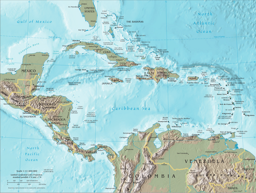
Russia’s oceanographic research vessel, the Admiral Vladimirsky, is currently making a scheduled visit to Cuba, its fourth long-distance voyage in the post-Soviet period. The ship left Kronstadt (near St.Petersburg) on March 13 and has already visited ports in Venezuela and Nicaragua.
The ship is conducting research in the Caribbean Sea, based upon requests from the National Hydrographic and Geodesy Service of the Cuban Military. Hydrographic research will be conducted in the waters of several Cuban ports. Hydrographic research involves the scientific measurement and description of physical features of water bodies, including oceans, seas, lakes, and rivers, along with adjacent land areas. It is crucial for safe navigation, understanding marine environments, and supporting various maritime activities. Cuba’s requests are almost certainly to assess port development for the country. The Caribbean Sea is one of the largest seas on Earth and has an area of about 2,754,000 km².
Russia will share the data obtained during this expedition with Cuba, Venezuela, and Nicaragua.
Since its construction in 1975, the Admiral Vladimirskiy has made over two dozen voyages to various parts of the world’s oceans, as well as to the Red, Mediterranean, Arabian, and Black Seas.
The Admiral Vladimirsky, previously, together with the vessel Faddey Bellingshausen, undertook a six-month Antarctic expedition lasting from December 1982 to May 1983, covering 35,000 nautical miles. Extensive studies of the parameters of the water and air environment were conducted, which made it possible to clarify the dynamics of many atmospheric and ocean processes. The nature of the Antarctic Circumpolar Current and the coastal countercurrent was determined. A unified scheme for the circulation of the waters of the Southern Ocean was proposed, and a number of unknown underwater mountains were found, while the coordinates of 13 islands were accurately measured. As a result, the Antarctic sailing directions were corrected, and the exact coordinates of the South Magnetic Pole were determined.
Such knowledge, like most other scientific research, can be used both for the benefit of fishing vessel crews and military ships. These vessels can solve problems of studying the marine environment for foreign customers and also ensure Russia’s participation in international treaties, for example, in the area of studying the waters surrounding Antarctica and the Caribbean.
Further Reading